Komoot – Cycling & Hiking GPS Maps
Price: Free | By: Komoot GMBH | www.komoot.com |

What does it do?
Ride tracking apps have been around for some time now, promising to turn your phone into a powerful mapping and recording device, or simply partnering up with your GPS to offer additional functions.
My first experience of this type of app was when Endomondo rocked onto the scene. Very quickly knocked off it’s perch by Strava, it ushered in a new breed of have-a-go hero. Soon, riders were racing every section of road or trail in a bid to capture the coveted KOM.
Komoot or Strava?
For Strava Addicts, the concept of Komoot will be confusing. The app can track your position and speed, just like it’s rivals. It also offers extra features to make it more interesting to those more interested in exploring than racing.
Komoot Collections
Komoot offers Collections which are basically activities that others have engaged in, shared, then organised by location. For example, there is the Dempster Highway in Canada (I can dream about riding that one) and Coastal mountain biking in the South of England (more realistic perhaps), plus many more.
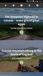
The Komoot Collections screen.
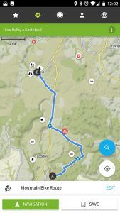
The Komoot Map view
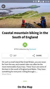
Collection overview screen.
Within each of these Collections are activities. Each one has a photo and a map, along with comments from people who have been there. There is also an opportunity for riders to share their experience or advice. It’s like a journal documenting the experiences of everyone’s personal adventures. It’s a concept that works really well.
Searching
You can also search areas for Collections or let the app suggest them based on your current location. For example, press the cycling icon and it shows rides that people have shared nearby. Currently the UK is a little sparse but as the user base grows, this community will expand with many more routes in the future.
You can plan Tours by setting start and end points. You can also go straight to the map and press the record button and begin recording an activity and simply ride away just as you would do with Strava. If you are familiar with route planners such as RideWithGPS or BikeHike, then you’ll be in familiar territory. But it’s the slick user interface and the whole integration of one simple app that makes Komoot stand out.
When the activity is completed, it can be saved. Even this offers far more than usual, allowing you to highlight points of interest and add photos taken along the way. The result is a growing journal of your personal activities that are superbly presented. You can choose whether to publicly share an activity or keep it private. By sharing, you effectively open up that ride, or Tour, in Komoot speak, to the wider community and allow others to download the route and follow on their own device.
Komoot isn’t just restricted to mobile devices; you can connect it to your Garmin or Wahoo GPS device to upload activities or push Tours to follow on your device. Plotting a route is always an easier task on a big screen and thankfully, the Komoot website is full of features making the task of planning your next adventure a total breeze.
The ADVNTR Team will be testing out Komoot long term and sharing our rides both here on our Routes section and with the Komoot community.
As always, we’d love to hear your comments and thoughts. Just scroll down to find our comments section.
Last modified: 20th November 2017


